Saturday bike ride with Washington ebike group – A 21 Mile Ride Through Hallowed Ground


Mile 0 – start and finish Auriga Farm. The land on which our farm ( built 1987) sits was originally part of a 2,628 acre land grant owned by Richard Blackburn in 1741. Our farm was at the very upper left hand corner of Blackburn's land grant where it fronted the 2 mile road from Bloomfield to Unison. As the decades passed Blackburn's land was subdivided, leased, and sold into smaller parcels, especially those bits of land along the main roads. However, in early 1800 an enterprising farmer, George Keen, began purchasing the small farms in the surrounding area along the Unison Road (formerly Loudoun Street, now Bloomfield Road). By 1850 he had built an estate of several hundred acres commanding both sides of the Unison-Bloomfield road stretching from town limit to town limit including the lands of Hastening Farm (C. 1750). In the 1930's the first electric lines were brought into the county, all the poles following the old roads, many which no longer exist except as bridle paths, or indentations in the ground on private property. The 100 year old power line poles that cut through our property are on a diagonal as they once serviced an old residence two farms away. All traces of that residence are now long gone with the exception of the line of electrical poles to point where it used to be. Keen’s land holdings were subdivided among his sons after his death, and further subdivided in the early 1980s by a group of investors who purchased from Keen's heirs the 160 acre Hastening Farm lands on the north side of Bloomfield Road. Those investors then carved the land into smaller landholdings including the lot for our farm.

Mile .2 - The gravel roads in southwestern Loudoun County are part of the Historic Roads District. Most of the roads travel along the base of the Blue Ridge Mountains eastern flank and offer stunning views of the mountainside. The Blue Ridge, part of the Appalachian range, was created by the uplifting of the Earth’s tectonic plates 1.1 billion to 250 million years ago and are among the oldest on the planet. At the time of their emergence, the Blue Ridge were among the highest mountains in the world, even higher than today's Himalaya Mountains. During the last several million years the Appalachian mountains fell and then rose a second time. They are in their second fall as a result of age and erosion. The mountains that you see along this route are about 1100 feet high. The highest peak, near Mount Weather, is 1700 ft.
Humans arrived in the Blue Ridge perhaps as early as 12,000 years ago. The Manahouac Indians were the most prevalent people living and hunting in the area of Western Loudoun County.

1 mile – Old Welbourne (480 acres in easement). Now on the National Register of Historic Places, Old Welbourne was settled by the Delaney family of Ireland in the early 1700s. The family built a log and stone cabin known as “original Welborne” (a stone dwelling now resides in the same spot), and when that house burned down in the early 1800s a second house, far more grand, was built in 1810. The new house was known only as Welbourne and was situated about 5 miles down the road. Several Civil War battles took place on the open lands around Old Welbourne in 1862. At the time of the Civil War, Welborne was owned by a family descendant, Colonel John Delaney of the Laurel Brigade, 7th Virginia cavalry, Confederate States of America. This manor house you see along this route was built by Colonel Delaney in 1878 for his maiden aunts who had continually complained to him that there was not enough room in the Welbourne house. Perhaps Colonel Delaney thought that if he build another manor house on the old grounds of the original house, he could get his aunts far enough away he would not have to listen to their complaints . We are sure that the aunts were more than enough satisfied with the extra space of the “new” house.

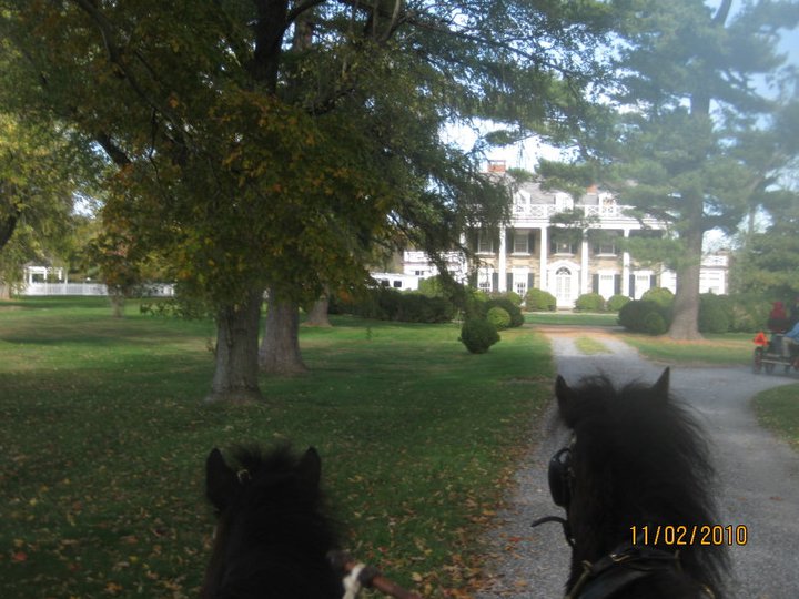
2 mile: Foxlease Farm (160 acres in easement) – the former home of John Archbold, the grandson heir to the Standard Oil fortune, and former Master of Piedmont Foxhounds (1940s to 1960s), was built in the 1920s as a fox hunting hideaway by the original owners who wanted to escape their New York winters by coming south in the winter to Virginia. It later became one of the premier Black Angus cattle breeding farms, and in the early 2000's was converted to a polo facility with two polo fields.
5 miles: Upperville Horse Show Grounds. Founded in 1853 it is the oldest continuously run horse show grounds in the US. It was established by Colonel Richard Henry Dulany (Old Welbourne) to encourage better treatment of young horses and improve the local breeding stock. Dulany, not to skimp on the prizes and prize money to encourage entries, went to Tiffany and Company of New York to have them design championship cups for the show. His efforts worked and the show became known as the very first horse show of its type in the nation in showing all types of breeds in different disciplines, plus mares and foals. It is the site of several of the most prestigious outdoor horse shows in the nation.

5.2 miles: Bio of Paul Mellon and Rokeby (highway marker signs). The Virginia Department of Historic Resources placed these two signs at the head of Rokeby Road honoring the late philanthropist and financier Paul Mellon and his world renowned racing stable Rokeby. The properties we will pass are located within the 18,000-acre Crooked Run Rural Historic District and the Mosby Heritage Area along the scenic roads spanning the villages of Middleburg, Upperville, and Paris, VA.

7.5 miles: Stop at the mountain overview and Mellon Airport. In the 1960's the land holdings of Paul Mellon and Robeby Farm was over 5,000 acres. 4,000 of those acres are in permanent preservation easement today. Paul Mellon lived here as a boy in the 1930s when it was purchased by his father, Andrew Mellon who was at that time US Secretary of the Treasury. He was a well known philanthropist of the arts, supporting the National Gallery of Art in Washington DC through the loan of several of his European painting collections, as well as the Museum of Fine Arts in Richmond, VA. He also funded the project “Protect Historic America” and underwrote the publication of “Hallowed Ground,” the pathfinding work that eventually led to the creation of “The Journey Through Hallowed Ground” project and organization which followed the consequential people, places and things along the route running from Mr. Lincoln’s battlefield at Gettysburg to Mr. Jefferson’s home in Charlottesville, passing directly though Fauquier County. Rokeby Farm was the birthplace of several famous racehorses, including Mill Reef winner of Europe’s most prestigious races in 1971; and Sea Hero, Kentucky Derby winner in 1993. The airstrip was put in around 1970 for Mellon's private jet. A quiet gravel road, just a bit south of the main property is also called Rokeby Road and leads down to the small town of Delaplane and the railroad depot that still exists today. Paul Mellon continued to use this farm as his Virginia base until his death in 1999.

10.6 miles: St. Brides (350 acres in protective easement). The lands were part of an original land grant from Lord Fairfax to Landon Carter in 1730. The main house on the property was built in 1812 near the ruins of the original log home. Dr. Cary D. Langhorne purchased the property in 1913 and three years later built a Georgian-style manor designed by Nathan C. Wyeth, architect of the Oval Office and the West Wing of the White House. The houses are sited out of view of the main road, but if you look closely at the fields surrounding this estate you will notice quite a few modern sculptures placed here and there for your viewing. The artwork is by various artists, both national and international, and is supported by the St. Brides Sculpture Foundation.

11.2 miles: Peace and Plenty Farm. This farm, with 366 acres in permanent protective easement, is from an original land grant of Lord Fairfax to Robert King Carter in 1702. Carter gave the property to his daughter, and through the decades the farm, a working horse and cattle operation, changed hands numerous times, yet continued to hold onto the stunning landscapes overlooking the Blue Ridge. The prior owner who resided here when the farm was called Bollingbrook (c. 1809) left when he was carted away to federal prison for illegally providing arms to Lybia. The property sat vacant for 15 years before it was purchased and restored by the current owner. On this property is a Cedar of Lebanon tree estimated to be over 250 years old.

13 miles: Upperville – a National Register of Historic Places, this town was founded in the 1790's sited at the eastern base of the Blue Ridge on the road leading to Winchester, Virginia. It was originally named Carrstown by the first settler Joseph Carr, but in 1819 the name was changed to Upperville by the Virginia General Assembly. In the early 1800s Upperville was considered a backwater frontier town with a rough reputation for a scurvy population devoted to drinking, gambling, and thievery. Since the town had only one main road going through it, the stagecoachs on their way east or west always had orders to gallop through Upperville and not to stop for any reason to prevent the local Highwayman from robbing the stages. After the Civil War life became more respectable in the town as the Highwaymen and rough elements disappeared into the jails or left for more fruitful opportunities elsewhere. Respectable business opened and flourished, the population became more wealthy and well-heeled, and even churches appeared to help the everlasting salvation of those mortal souls living in the area. The town still retains only one road through it, now known as State Route Highway 50. It also retains almost all the prior buildings dating back to the earlier centuries, all fronting on St. 50.

14.9 miles: Ayrshire Farm (793 acres). This farm is the 2nd largest conservation easement land in Virginia. First settled in the 1800s by a Scotsman named George Ayre, the estate totaled about 860 acres. Several Civil War skirmishes and battles took place around the farm, and at one point Colonel Mosby was standing in the manor house's picture window and a passing Yankee soldier took a pot shot at him. Fortunately, or unfortunately depending which side of the war you were on, the bullet missed. Later during the war Ayre's horse and saddle were confiscated by the Federal troops for Ayre having helped the Confederates. Unfortunately, Ayre had hidden $40,000 in his saddle in case of a raid. Definitely a poor hiding spot as neither the horse nor saddle nor money was ever recovered. Ayre sold the farm after the war and it eventually became the property of retired Army General Buchannan who had been the Governor of Puerto Rico after the Spanish American war. With the old manor house in disrepair, Buchannan built a new manor house in 1814. In 1962, Alfred Hitchcock filmed parts of the movie "Topaz" at Ayrshire, specifically the driveway heading up to the main house. The house and property remained in the same family for over 80 years until 1996 when the farm was sold to Sandy Lerner, founder of Cisco Corporation. A long-time philanthropist and advocate of animal rights, Lerner remains passionately committed to organic, humane farming and the preservation of farmland and open spaces in Virginia’s Piedmont.

15.5 miles: Llangollen Farm - one of the largest privately owned places on the Department of the Interior's National Historical Registry, Llangollen dates back to 1795 with 1,100 acres of rolling terrain, including 350 acres of mountain woodland on the eastern slopes of the Blue Ridge. It has the distinction of being first surveyed by a young George Washington in the late 1700s and having been visited after the Revolutionary War by French military officer Lafayette. The farm has stood witness to a particular harsh Civil War battle - The Battle of Upperville – where troops raged for several days on the fields and valley of the estate. After the war the estate returned to farming until it was purchased in the 1920 by Jock Witney, a gilded age playboy-millionaire. Whitney, nonetheless, was more than just a gadabout. He was a trustee of the Museum of Modern Art, bought and ran the New York Herald Tribune, and served as ambassador to Great Britain. He expanded the acreage of Llangollen and built the manor house seen today as a wedding present to his bride, the beautiful Liz Altemos of Philadelphia. As soon as she took of residence Liz built a horse shoe shaped stable behind the manor house for her prized Thoroughbred breeding horses, and her collection of carriages. Whitney was a firm believer in the art of motion pictures and helped finance David O. Selznick's 1939 picture “Gone With The Wind” which won that years academy award for Best Picture. Liz tried out for the part of Scarlet, but the screen test was merely perfunctory as Selznick already had Vivian Leigh in mind to play the part. While lunching with Whitney at Llangollen one day, Selznick noted Llangollen's 1 mile long driveway to be the perfect background model for Ashley's homecoming in the movie. When the Whitneys divorced in the 1940's Liz kept the property and raised prize winning racehorses and show horses until her death in 1988, leaving the house and buildings in a serious state of disrepair. The property was sold by the trustees to Roy Ash, a California businessman who served in the Richard Nixon and Gerald Ford administrations. He restored the mansion to its former glory and lived there until 2006 when it was sold for $22 million to Donald Brennan, who was the onetime chairman of crystal and fine china maker Waterford Wedgwood PLC, and the former head of Morgan Stanley Capital Partners. The 1,100 acre property is now for sale at $34 million.
16.2 miles: Corotoman -original land grant from Lord Fairfax to Robert “King” Carter. Robert “King” Carter was born at Corotoman Plantation in Lancaster County, Virginia, and at age 28 he entered the General Assembly of Virginia as a Burgess from Lancaster County. In 1726, as President of the Governor’s Council, he served as acting Governor of Virginia after the death of Governor Hugh Drysdale. As an agent of Lord Fairfax Carter he served two terms totaling nearly 20 years for the Fairfax Proprietary of the Northern Neck of Virginia. He began to acquire large tracts of land for himself in the Rappahannock River region of Virginia as well as 110,000 acres of additional land in Virginia near the Blue Ridge Mountains, earning himself the nickname of “King”. At his death he left his family 300,000 acres of land and 3,000 slaves in the colony of Virginia. Lord Fairfax, who had no idea of the extent to which his land agent had amassed such a fortune of Fairfax's land, was reported to be both astonished and furious when he saw Carter's will. Fairfax, knowing had been bamboozled by the best, vowed never to use another land agent outside his own family. But the deed had been done, and the Carter family flourished on their lands in the New World. The original Corotoman in lower Virginia burned to the ground in 1729, so when the great granddaughter of “King” Carter was given a tract of land just east of the Blue Ridge above Upperville, she named her new estate Corotoman in deference to the family's original seat in Virginia. The manor house was built in the woods, and the field stock and farm was tended to by the estate slaves. The ravages of the Civil War hit Corotoman hard, and with the horses and stock and some slaves as well being “freed” ( as in “absconded”) by the Yankee troops, the Carter family was quite peeved. After the war ended life resumed but not without the ire of the owner who instituted in the neighborhood a “Yankee No” rule to prevent any northerners from becoming members of the foxhunt, or buying property in the area. The financial recessions and depressions following the Civil war, however, soon trampled that rule into dirt as New Yorkers and Philadelphians flocked to the area snapping up cheap land from the impoverished and distressed local families. The area around Upperville went from ownership by old southern monied families to Neuveux Rich northern families in a blink of an eye. Corotoman's old manor house fell into disrepair as a new manor house was built in about 1900, now the residence of the Thompson family. In 2009 Corotoman was awarded the Virginia Clean Water Award for its exemplary efforts to help keep the natural watershed and streams running through the property clean of farm runoff and debris.

18 miles: Newstead Farm - Newstead has a long and storied history as one of the premier thoroughbred breeding farms in the area. The original owner, Taylor Hardin, was a Yale graduate who came south to Virginia after his graduation in the Roaring Twenties. He purchased the current 356 acre farm in 1936 to establish a thoroughbred breeding farm and to indulge in his favorite sport of foxhunting. His first wife, however, wasn't pleased at all with her husband's love of Virginia and stayed behind in New York through their subsequent divorce. Hardin then married a more willing partner who was happy to be in Virginia and help him build the future Newstead Stud. Several of the farm’s thoroughbreds brought first record setting prices at the bloodstock sales from the 1950s through the 1980s when one of their thoroughbreds was the first to sell for $1 million dollars. Newstead Farm was sold in 1991 to the Firestone family who had been forced to sell their thoroughbred breeding farm in Waterford, VA for running afoul of the Irish courts when they tried to sell some of their nationally protected land in Ireland to Japanese investors. The Irish courts slapped down that sale, and the Japanese investors, stung by the rebuke, demanded restitution which came in the form of the Firestones having to substitute their Waterford Virginia property for sale instead. They subsequently purchased Newstead and moved their entire operation to the Upperville farm. The Firestones owned the 1980 Kentucky Derby winner “Genuine Risk”, only the 2nd mare to have won that prestigious race. Genuine Risk died at 31 years of age in 2008 in her paddock at Newstead Farm and is buried in a honored grave in front of the manor house. The farm sold for $9.5 million in March 2020.
20.1 miles: Bloomfield - On January 1816 the Virginia General Assembly established the town of Bloomfield a mere three years after the establishment of its neighbor village of Union/Unison. Bloomfield became a thriving town and in 1830 was recorded as having a population of 59 with 12 dwellings and businesses. Bloomfield was often called by its nickname "Frogtown" because of the early spring peepers in the fields surrounding the area. In 1863 during the Civil War Colonel John Singleton Mosby and his partisan Rangers robbed a Federal payroll train in West Virginia of $173,000. The Raiders then hightailed it to Bloomfield to divide the loot. This blatant daylight robbery incurred the wrath of the Federal army who stormed into Virginia in search of the Rangers, burning villages and farms as they went. But the Rangers had long since scattered with the loot - money worth a lifetimes wages for most of the men. After the war the town continued to prosper until the 1950s when bigger towns and the new highways took away the local trade. The last business in the town to remain was Freeman store which operated from 1914 until 2000 when it closed with the death of the last owner. It is now a Pottery Shop devoted to the art of handmade ceramic pots.
21.2 miles: End at Auriga Farm
The route Cue sheet will be added to the printed tour guide booklet.
|